Central and Southeast Texas are currently under a serious weather watch as a stalled front dumps deep tropical moisture across the region. With widespread flash flood warnings active from Houston to Austin, the atmosphere is reaching a breaking point, with meteorologists projecting an additional 4-7 inches of rainfall through mid-week. For Houston, this weather event presents a dual challenge: protecting local infrastructure while managing the massive influx of visitors currently in town for the 2026 FIFA World Cup matches. The risk of rapid, localized flooding is high, and the NWS is urging all residents and event attendees to prioritize safety over schedules.
Navigating this crisis requires more than just checking a weather app; it demands a proactive mindset toward public safety and property protection. Whether you are navigating the traffic-heavy roads near the stadiums or securing your residence against the rising tide, awareness is your first line of defense. As the situation remains fluid, understanding how to read localized alerts and taking immediate, preventative steps at home will be the deciding factor in how your household weathers this storm.
Severe Weather Alert: Central and Southeast Texas Flash Flood Crisis
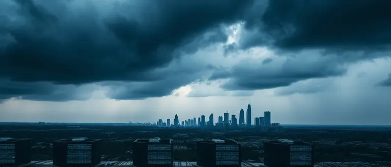
As of June 14, 2026, a significant atmospheric event is unfolding across the Lone Star State, necessitating an urgent flash flood warning for large swaths of Central and Southeast Texas. Meteorologists identify the catalyst as a stalled weather front interacting with a persistent surge of deep tropical moisture. This convergence is creating an environment ripe for high-intensity, slow-moving storms, with the National Weather Service (NWS) projecting rainfall totals between 4 and 7 inches across the region through the mid-week period. This moisture-rich system is causing substantial concern for regional infrastructure, particularly in areas already saturated from earlier seasonal rains.
Impact on Houston and Austin
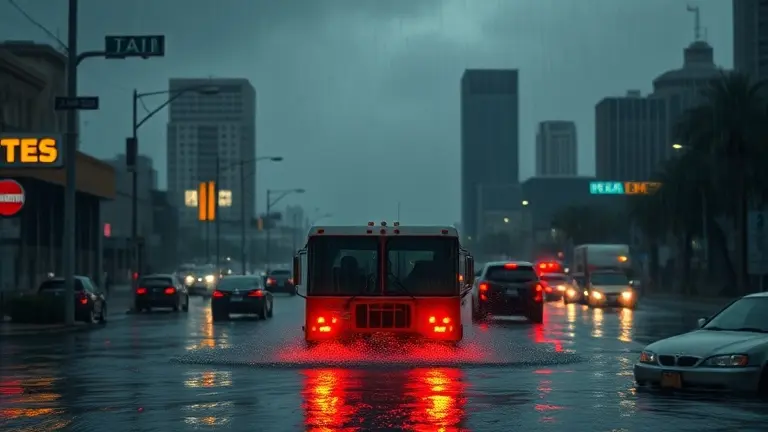
The timing of this severe weather is particularly challenging for the state’s major urban centers. In Houston, where 2026 FIFA World Cup matches are currently underway, the influx of international tourists and local fans complicates traffic management and public safety. City officials and emergency services are working in tandem to monitor high-traffic event zones, where local drainage systems may be tested by the forecasted rainfall. Similarly, residents tracking austin weather patterns are bracing for significant travel disruptions, as flash flooding often impacts low-lying crossings and major thoroughfares throughout the capital region.
Critical Safety Considerations
The intersection of major public events and extreme weather requires heightened vigilance from both residents and visitors. To ensure personal safety and minimize exposure to hazardous conditions, follow these established guidelines:
- Monitor Real-Time Alerts: Stay connected to local NWS updates and local media, such as ABC13 or KXAN, for specific flash flood warning austin notifications.
- Avoid Submerged Roadways: Adhere to the “Turn around, don’t drown” protocol; never attempt to drive through standing water, as the depth and force of the current are often deceptive.
- Event Planning: World Cup spectators should check official matchday transit updates before departing, as road closures and transit delays are highly likely throughout the Houston metropolitan area.
- Emergency Preparedness: Maintain a disaster supply kit and ensure that your mobile devices are charged to receive emergency alerts as the Flood Watch remains in effect through June 17.
By remaining informed and prioritizing safety over travel convenience, the public can navigate this critical weather window with greater confidence and significantly reduced risk.
Real-Time Flood Mapping and FIFA World Cup Site Safety
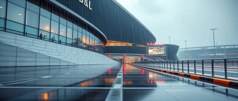
As Houston weather conditions remain volatile due to a stalled tropical moisture system, fans attending the 2026 FIFA World Cup must prioritize situational awareness. With a flash flood warning currently in effect, localized flooding poses a significant risk to transit routes near major stadium venues. Spectators are urged to move beyond standard weather forecasts and utilize high-resolution, real-time flood mapping tools provided by the National Weather Service and local municipal authorities. These interactive platforms allow users to overlay stadium proximity with live road closure data, which is essential given that 4-7 inches of rainfall could render secondary roads impassable within minutes.
Essential Safety Protocols for Stadium Commuters
To ensure personal safety and minimize event disruptions, event attendees should follow these actionable guidelines before heading to the match:
- Monitor Localized Alerts: Use the NWS Houston office’s live flood tracker to identify low-lying intersections near transit hubs. If a flash flood warning is issued for your specific zip code, avoid low-water crossings entirely.
- Integrate Venue-Specific Updates: Check official FIFA fan portals alongside local weather Houston feeds. Often, transit authorities will reroute shuttles to avoid flooding, and real-time updates are pushed directly through event-specific mobile applications.
- Adhere to ‘Turn Around, Don’t Drown’: Never attempt to drive through standing water, even if it appears shallow. During peak events, drainage infrastructure can be overwhelmed, and hidden hazards like open manholes or debris pose lethal threats to vehicles.
- Transit Alternatives: If you are traveling in Austin or Houston, prioritize heavy rail or dedicated event-shuttle bus lanes over private ride-sharing services, as these dedicated paths are frequently the first to be cleared and monitored by emergency management teams.
By combining these digital tools with conservative travel planning, fans can enjoy the World Cup experience while mitigating the risks posed by this extreme weather event. Always maintain a 48-hour outlook, as the potential for rapid accumulation remains high through mid-week.
Essential Safety Protocols: ‘Turn Around, Don’t Drown’

As weather Houston and austin weather patterns continue to fluctuate with heavy tropical moisture, the National Weather Service (NWS) is emphasizing the “Turn Around, Don’t Drown” protocol. For those navigating the region, especially spectators attending the 2026 FIFA World Cup in Houston, understanding the mechanics of flash flood warning zones is critical. It takes as little as six inches of moving water to reach the bottom of most passenger cars, potentially causing loss of control or engine stalling. Twelve inches of flowing water can carry away most vehicles, and two feet will sweep away even large SUVs and trucks. If you encounter a flooded roadway, never attempt to drive through it; the depth of the water is often deceptive, and the road surface beneath may be completely washed away.
Identifying Hazardous Road Conditions
When traversing Southeast and Central Texas, remain vigilant for signs of dangerous accumulation. Austin flooding and Houston drainage issues frequently impact low-lying areas, particularly near bayous and creek beds. Use this checklist to stay safe during the next 48-72 hours:
- Avoid Underpasses: These are the most dangerous areas for drivers, as water collects rapidly, often trapping vehicles before they can be evacuated.
- Observe Road Barriers: If a road is marked with barricades or signage indicating a closure, do not bypass them. These barriers are placed by authorities who have already identified impassable conditions.
- Monitor Real-Time Data: Use local transit apps and official government traffic feeds to identify active road closures before departing for your destination.
- Headlights On: Increased visibility is essential during heavy downpours. Maintain a safe following distance and be prepared to stop if conditions deteriorate.
For event attendees, the safest strategy is to plan alternative routes that avoid known flood-prone districts. If you are stuck in traffic and observe rising water, move to higher ground immediately and abandon your vehicle if necessary. Prioritize your safety over punctuality; arriving late is preferable to becoming a victim of a rapid-onset flash flood.
NWS Projections and Next 72-Hour Preparedness

The National Weather Service (NWS) has issued a comprehensive Flood Watch effective through June 17, as a stalled weather system draws deep tropical moisture into the region. For residents monitoring weather Houston patterns and those navigating Austin flooding risks, the primary concern is the potential for 4-7 inches of rainfall across localized sectors. This high-volume precipitation is expected to occur in sporadic, intense bursts, creating a significant flash flood warning threat that requires careful coordination for those involved in 2026 FIFA World Cup festivities.
72-Hour Timeline and Risk Windows
To maintain safety and minimize travel disruptions, stakeholders should anticipate the following schedule:
- June 14–15: The initial phase of the storm system brings widespread moisture, with intermittent heavy downpours. Low-lying urban areas and poor drainage zones are at high risk for rapid water accumulation.
- June 16: This remains a critical window. Expect the highest potential for localized flash flooding as the atmosphere reaches saturation. Commuters and event attendees should prioritize alternative transit and monitor real-time updates for sudden road closures.
- June 17: Residual moisture persists, though intensity is expected to taper off. Stay alert for lingering road hazards and standing water as infrastructure works to drain the accumulated volume.
For fans attending World Cup matches in Houston, the intersection of dense crowds and volatile weather Houston conditions necessitates proactive planning. It is essential to treat every flash flood warning as a signal to avoid low-water crossings entirely, adhering strictly to the “Turn around, don’t drown” protocol. By aligning travel plans with these NWS projections, visitors can ensure a safer experience despite the environmental challenges. Always prioritize official alerts from the NWS over general social media commentary to maintain an accurate assessment of current risks.
Securing Your Home Against the Rising Tide
As the rain continues to fall across Texas, moving from passive concern to active preparation is essential. While keeping an eye on official NWS alerts and local traffic maps is crucial for your personal safety on the roads, you cannot ignore the physical integrity of your property. Heavy rainfall of this magnitude often finds the weakest points in our homes, turning a standard storm into a costly disaster. Taking control of your home’s defense is the most effective way to minimize the stress of these severe weather cycles.
Beyond protecting yourself while traveling, securing your home’s integrity is vital during these stalled weather fronts; having the right construction plans ready can be the difference between a minor cleanup and significant property damage. This is where Ted’s Woodworking becomes an invaluable asset for every homeowner. By providing instant access to over 16,000 professional-grade workshop plans, this resource empowers you to quickly build the custom flood-mitigation barriers, raised platforms, and water-deflection infrastructure your property desperately needs right now.
Don’t wait for the water to reach your doorstep. By utilizing these expert-verified blueprints, you transition from a victim of the weather to a proactive protector of your investment. It is the smartest, most practical step you can take to harden your home against the 4-7 inches of rain currently bearing down on our region.
 Download these workshop-tested plans now to build the custom flood-mitigation barriers your property needs before the next wave of rain hits.Yes, I Need These Plans Now!