
As of April 13, 2026, the Upper Midwest is entering a volatile phase of the spring transition, with meteorological activity ramping up across Minneapolis, Milwaukee, and beyond. For homeowners, the constant ping of weather alerts often feels like a background hum, yet the intensity of recent convective outlooks issued by the Storm Prediction Center (SPC) serves as a critical reminder: spring weather here is far from predictable. Whether you are tracking the latest storm front or navigating the nuances of severe thunderstorm warnings, your priority remains the safety of your family and the structural integrity of your home.
Understanding the difference between a ‘Slight Risk’ and an ‘Enhanced Risk’ is more than just interpreting map colors—it is about assessing your personal level of exposure. While meteorologists provide the data, the responsibility for securing your property rests on your shoulders. In this guide, we break down the technical jargon of the SPC and provide actionable, structural steps to fortify your home against the unpredictable nature of Midwestern spring storms.
You don’t have to be a meteorologist to build a storm-ready defense. By shifting your approach from reactive monitoring to proactive fortification, you gain the peace of mind that comes with knowing your home is reinforced against the elements. Let’s dive into how you can effectively translate those weather warnings into tangible safety actions.
Current Weather Alert: Severe Storm Risks Across the Upper Midwest

As of April 13, 2026, the Upper Midwest is facing a period of heightened atmospheric instability, driving a surge in storm tracking activity across the region. Meteorological data from the Storm Prediction Center (SPC) indicates that the spring transition season is in full effect, characterized by strong temperature gradients and deep-layer wind shear that favor the development of organized convective systems. Residents in both Minneapolis weather zones and the Milwaukee weather corridor should remain hyper-vigilant, as these fast-moving systems frequently produce hazardous conditions, including damaging wind gusts, large hail, and localized flooding.
Understanding Your Local Risk
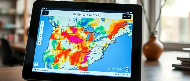
The SPC’s convective outlooks are currently identifying specific geographic clusters that face a higher probability of severe weather development. When checking the weather Minneapolis reports or tracking regional radar, it is vital to understand that technical designations reflect the likelihood of hazardous phenomena within 25 miles of any point:
- Marginal/Slight Risk: Indicates an environment capable of producing isolated to scattered severe storms.
- Enhanced/Moderate Risk: Suggests a more concentrated threat of significant wind damage or intense convective activity.
Because the atmosphere in the Mississippi River Valley can destabilize rapidly during this time of year, conditions can shift from “sunny and mild” to “severe” in a matter of hours. The National Weather Service (NWS) emphasizes that residents should not rely solely on sunshine as an indicator of safety. Instead, rely on official SPC convective outlooks and local NWS alerts to stay ahead of the weather. By monitoring your local forecast, you can better prepare your property—such as securing loose outdoor furniture and clearing gutters—before the storm front arrives. Always prioritize life safety by identifying your designated shelter area immediately upon seeing an active severe thunderstorm watch or warning for your county.
How to Interpret SPC Convective Outlooks
Understanding a storm forecast requires more than just checking your local app; it involves interpreting the convective outlooks issued by the Storm Prediction Center (SPC). These forecasts are designed to identify areas where organized thunderstorms are expected, providing a roadmap for potential severe weather threats. When reviewing weather Minneapolis or Milwaukee weather alerts, the SPC uses a standardized five-level categorical scale to communicate the likelihood and intensity of severe weather. Translating these technical categories into household urgency is the first step in effective disaster mitigation.
Decoding SPC Risk Categories
The SPC convective outlooks are calibrated based on the probability of severe winds, large hail, or tornadoes occurring within 25 miles of a point. Homeowners should view these categories as a baseline for their safety preparations:
- Marginal (Level 1): Isolated severe thunderstorms are possible. These are typically short-lived and not widespread, but property owners should still monitor local updates.
- Slight (Level 2): Scattered severe thunderstorms are expected. These storms can be short-lived or isolated but may produce localized damage.
- Enhanced (Level 3): Numerous severe thunderstorms are possible. This risk level often involves more persistent, organized weather systems that warrant heightened vigilance.
- Moderate (Level 4): Widespread severe thunderstorms with a significant potential for structural damage. This requires proactive safety measures and a completed emergency plan.
- High (Level 5): A severe weather outbreak is expected. This is the most dangerous tier, indicating a high confidence in widespread, intense convective activity.
When these outlooks are issued for the Upper Midwest, they serve as a critical tool for residents to assess their risk level. Rather than waiting for sirens, use these categories to determine your level of preparedness. If a region enters an Enhanced or Moderate risk, secure outdoor furniture, clear gutters to prevent drainage issues, and ensure your communication devices are charged and ready to receive NWS alerts. By understanding the severity behind these professional meteorological maps, you can better protect your family and property during volatile spring transitions.
Midwest Homeowner’s Checklist: Protecting Your Property

When the Storm Prediction Center (SPC) issues a convective outlook for the Upper Midwest, residents from Minneapolis to Milwaukee should act quickly to safeguard their homes. Spring transition periods frequently bring volatile convective activity that can cause significant property damage in minutes. Proactive maintenance is the best defense against high winds and large hail, which are common hallmarks of Minneapolis weather and the broader Great Lakes storm systems. By securing your physical assets before a storm arrives, you significantly reduce the risk of structural failure or water intrusion.
Pre-Storm Property Maintenance
Routine maintenance prevents minor weaknesses from becoming major repair bills during a severe weather event. Prioritize these tasks when the forecast indicates active weather:
- Secure Outdoor Items: Bring in patio furniture, portable grills, and potted plants. High winds can turn these items into dangerous projectiles that break windows and damage siding.
- Clear Gutters and Downspouts: Ensure gutters are free of spring debris. Clogged systems cause water to overflow and pool near your foundation, increasing the risk of basement flooding.
- Inspect Roof Shingles: Walk the perimeter of your home to check for loose, damaged, or missing shingles. A compromised roof is highly susceptible to wind uplift, which can lead to interior water damage.
- Reinforce Windows: If you are in the path of a severe system, consider closing all blinds and curtains. In the event of high-impact hail, having a temporary interior barrier or moving to an inner room away from glass is critical for safety.
By treating these forecasts as actionable alerts rather than just background noise, you protect your biggest investment from the unpredictable nature of spring weather in Minneapolis and surrounding regions. Regular inspections combined with rapid response times remain the most effective strategy for mitigating damage during the height of the convective season.
Building Your Personal Emergency Action Plan
When Minneapolis weather or Milwaukee weather reports shift toward severe classifications, the difference between panic and preparedness lies in your pre-established plan. A robust Emergency Action Plan moves beyond reactive browsing of the SPC (Storm Prediction Center) convective outlooks by formalizing how your household responds to a rapidly developing storm. You must identify a designated “safe zone” in your home long before sirens sound. Ideally, this is a basement or an interior room on the lowest level, away from windows, glass, and exterior walls. If your residence lacks a basement, prioritize a small, windowless interior closet or bathroom that provides the shortest path to safety.
Essential Components of Your Preparedness Strategy
To ensure your family remains secure during convective events, maintain a comprehensive “go-bag” and redundant communication channels. Relying on a single source of information is a significant vulnerability during volatile spring conditions. Instead, implement a multi-source alert strategy:
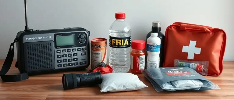
- NOAA Weather Radio: Maintain a battery-powered unit to receive official alerts directly from the National Weather Service (NWS), even during widespread power outages.
- Mobile Alerts: Enable Wireless Emergency Alerts (WEA) on your smartphone, but supplement them with hyper-local apps that provide real-time tracking for weather Minneapolis and surrounding urban corridors.
- Emergency Go-Bag: Assemble a portable kit containing non-perishable food, one gallon of water per person, a manual can opener, a high-quality flashlight, extra batteries, a portable power bank for smartphones, and a first-aid kit.
- Documentation: Keep physical copies of critical insurance documents and identification in a waterproof container within your safe room.
By proactively mapping your evacuation route or identifying your internal shelter location, you remove the burden of decision-making during high-stress moments. Regularly practice this drill with all household members, ensuring everyone knows how to interpret the difference between a “watch”—where you remain vigilant—and a “warning,” which mandates immediate action. Taking these steps today transforms technical meteorological warnings into actionable safety behaviors, protecting your family and your property when it matters most.
Transform Your Home Into a Storm-Resistant Fortress
While monitoring SPC outlooks and having an emergency plan are the foundational pillars of safety, the ultimate protection for your household lies in the physical reinforcement of your property. Weather alerts can tell you when a storm is coming, but they cannot stop flying debris or mitigate structural vulnerabilities. True preparedness means taking control of your home’s defenses before the next front arrives, ensuring that your property is as resilient as possible against the unpredictable spring weather.
While understanding meteorological alerts is the first step to safety, the most effective way to protect your property from spring storm damage is through structural reinforcement. This is where Ted’s Woodworking becomes your essential toolkit for home hardening. By providing you with workshop-tested plans, this resource empowers you to build durable, storm-resistant structures—from reinforced storage units to protective outdoor reinforcements—with absolute technical certainty. You no longer have to guess how to build correctly; you can now execute professional-grade property protection projects that minimize damage and maximize your peace of mind.
Don’t wait for the next severe storm to realize your property needs extra reinforcement. Move from a passive observer of weather alerts to an empowered protector of your home. Gain the technical precision to secure your assets with ease and ensure your property stands strong through the height of the season.

Download these workshop-tested plans to start building your storm-ready home defenses today.
Get Yours Now